The tramline reaches Kureelpa
Acting
on Dr Maxwell's advice, the Government decided to resume construction of the
Dulong tramline up the Highworth Range from Murtagh's along the previously
roughly-surveyed route.
A
problem immediately arose when the section of line from the Mill to Highworth
was checked by Government Engineers and found to be unsuitable for traffic.
For the first three miles, the sleepers were found to be too far apart, and
the rails on curves, forced into position with crowbars when being laid, were
gradually straightening, leaving the line a series of kinks rather than smooth
curves. The line from Highworth towards Image Flat was barely fit for horse
haulage and needed to be completely relaid.
Improvements
to both of these sections began at once, and the relaid line was back in use
as far as F. M. Murtagh's house by 1902. The new Minister for Agriculture,
Mr D. F. Denham, visited the area that year to inspect progress. On the
uplands of Kureelpa, he saw that the farmers had laid a mile of portable track to
transport cane to the edge of the Highworth Range escarpment. He noted the
'flying foxes' that had been run from the edge to the terminus of the
tramway, and heard how bundles of cane were sent down the wires to the
tramline below. This was only a temporary measure until the tramway could be
extended to Dulong.
Surveying of the tram route up the steep slopes to the top of the Highworth Range was
conducted firstly by William Morrow and then by Henry Pope. It would take the
end of track to 4 miles 20 chains from the Mill. Reports at the time claimed
that Pope had a 'weakness for tunnels', for he included one, possibly two
on the route. When work on the No. 1 tunnel was due to begin, the contractor
reported that in his opinion it 'would not stand', as it passed through a
low spur and the roof of the tunnel would be too close to the land surface. In
addition, the tunnel would need to be curved. In the event, a 40 feet deep
cutting was used instead.
The whole construction up the Highworth Range was a major engineering challenge, involving very steep gradients and many twisting curves. The sharpest bend was a horseshoe curve at the head of a narrow gully on the north side of the Nambour to Mapleton road.
In some sections the line ran along carriageways (such as Puddle's Road), in others through easements specially surveyed for the purpose (such as just south of the Mapleton Road, west of its junction with Henebery Road). Much of the line passed through private properties, through which running rights were agreed on between the owners and the Mill company.
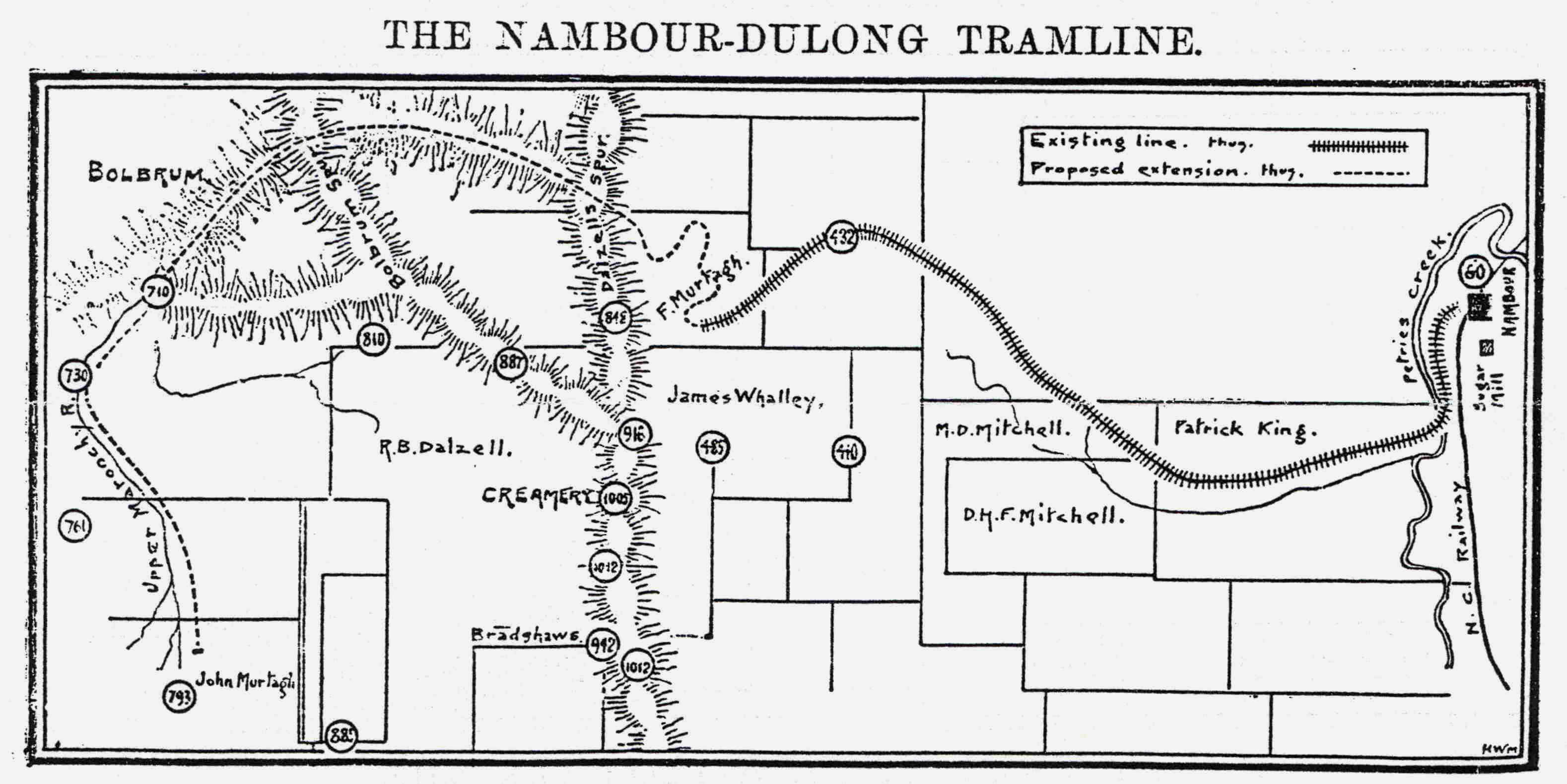
The map above was published in the Queensland Agricultural Journal of 1st January 1903, on page 48. The numbers in circles are heights (in feet) above sea level. It shows the Nambour - Dulong Tramline as it then existed, terminating at F. M. Murtagh's farm below the Highworth escarpment. A dotted continuation shows a proposed extension to John Murtagh's property at Dulong, about halfway along what is now Sherwell Road. In the event, the proposed extension as shown was only partially built.
By
1903 the line had reached the summit of the Highworth Range at Doig's Point,
overlooking the edge of the escarpment. As funds became available, it was
extended until by 1904 it had reached the site of the Kureelpa Hall, 6 miles
20 chains from the Mill.
This whole section from Kureelpa Hall to Dulong was only in regular use
carrying cane for about six years. Growth of sugar cane was soon found to damage the soil and cause erosion, but the farmers persisted until 1908, when a particularly cold winter caused severe frost damage to crops.
To
provide access to cane fields not serviced by the main tramline or spurs,
sections of portable track were laid temporarily, and then moved by horse or
manpower to other locations. They were connected to the permanent way when
needed, by means of riding or jump points. Farmers used wagons and wooden
slides drawn by their own horses to cart the cut cane sticks to the nearest portable line or
to a siding.
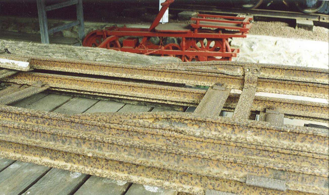
Riding or jump points were placed when needed on top of the main line to connect it with temporary portable sidings. Only cane trucks and wagons could negotiate these 'points', definitely not locomotives. These have been placed on top of portable track with pressed steel sleepers. Note that the spacer on the riding point extends down to prevent the point rails from slipping off the rails below. These examples are preserved by Clive Plater of Eudlo.
The
lands to the west of Nambour, including Burnside, Perwillowen, Image Flat,
Highworth and Kureelpa, became important cane-growing areas and by 1920
produced 75% of the cane crushed by the Moreton Central Mill. This was because
the kinds of cane being grown at the time did not do well in low-lying frost-
and flood-prone areas, but thrived on higher, well-drained ground.
This led to a reduction in the growth of cane west of Nambour, and production gradually diminished in the Mapleton-Kureelpa area during the 1930s. This aerial photograph shows that a few cane farms were still in existence north-west of the Kureelpa Hall in 1940, these had been turned over to dairying by 1945.
This aerial photograph taken the same day in 1940 shows a small amount of cane still being grown at Mapleton in the area between Post Office Road and the swamp, but this was soon phased out. Cane growing continued in the Perwillowen and Burnside areas until 1970.
In the early years, the rakes of cane trucks were hauled by horses all over the tramway network. At the Highworth Range, now usually known as the Dulong Range, horse teams hauled the empty wagons up the steep gradients. It was judged that a load of four tons, equal to seven or eight empty cane trucks, was the limit for a team of four horses.
The
hardest drag for horses with loaded cane trucks on the Kureelpa section was
the gradient of 1 in 33 through Doig's farm, terminating at Doig's Point on
Kureelpa Falls Road.
Each horse team could manage just two fully loaded trucks on this section, and
the trucks would be placed in a siding located there.
In late 1903, a reporter and an artist/photographer from the Queensland Agricultural Journal were invited to pay a visit to the Mapleton area. They published their story in the issue of 1st December of that year. After leaving Mapleton, the journalists had ridden on borrowed horses down to Kureelpa, where they were offered a ride on a trolley, down the tramline to the Mill at Nambour. They described this exploit in their report:
"A trolley had been placed at our disposal by the engineer and Mill manager, the courteous Mr Lunn. We were to do the return journey at whatever time suited us, without waiting for a man or a rake of trucks. When we decided to return, our artist, Mr Mobsby, elected to drive, or rather to brake. Of course, we had no horses. We were going to run down an incline all the way. As an artist, we have the deepest respect for him, but as a motorman our respect has considerably diminished.
The
Chronicle
of 28th September 1907 included a report describing a three-day
tour made by the Mill Directors (at that time they were Messrs J. Reid, J.
Currie, J. Pedler, G. L. Bury and F. M. Murtagh) over the Moreton Mill
tramways during the previous fortnight. On the last day of their trip, the
Directors and some other Mill staff had travelled over the Dulong line,
travelling up the steep ascents on two cane trucks drawn by three horses
driven by contractor Mr C. Burke.
Their destination was the farm of Mr R. Whitecross, 7 miles 40 chains from the Mill.
This would indicate that they traveled up the Dulong line to its terminus
near Dulong Road.
The party then proceeded to Doig's Point at the top of the Highworth Range where
the horses were unhitched. Mr Burke then walked the animals down through the
scrub to Image Flat. The party boarded the two cane trucks, and then coasted
about two miles down the precipitous switchbacks to Highworth and then another
mile down the Image Flat branch. There they met up with Mr Burke, and his
horses pulled the party back up to Highworth. They then coasted down to
Nambour, braking being capably handled by Tramway Foreman Mr H. Major.