Alfred Delisser surveys the Blackall Range
As mentioned previously, an early
surveyor, C. S. Bradbury, had named the Blackall Range in 1874 after a popular
Governor of Queensland. In the next fifteen years, the occasional settler,
timber getter or Government surveyor would force a way through the scrub up to
the top. Some pioneers selected land in the areas which were to become Maleny,
Montville and Flaxton, but before 1889 no-one settled on the northern end of the
Range, as there was plenty of excellent land available closer to the coast.
Alfred Delisser (1832-1904) and his brother Edmund Alexander Delisser (1829-1900) were English contract surveyors in their twenties who arrived in Melbourne in 1857. In the 1860s Edmund led survey parties that included Alfred, and in 1866 they surveyed lands north of the Great Australian Bight. This work was done for the DeGraves pastoral company, and Edmund named the Nullarbor Plain from the Latin nulla (meaning 'no') and arbor (meaning 'tree'). Over the next twenty years they worked either separately or together in various Australian states (although those were still only separate colonies, statehood would not arrive until 1901). By 1880 both men were in Queensland, where they undertook surveys for private individuals and companies, but mostly important work for the Government, surveying crown land for roads and railways. Most of Edmund's work was done in North Queensland, and he was responsible for the first railway route from Townsville to Charters Towers. This involved a difficult ascent over the Haughton Range with 1 in 25 grades and 3.5 chain (65 metre) radius curves, and the line was officially opened to traffic on 4th December 1882. The line was successful, but trains took over five hours to cover the 140 kilometres between Townsville and Charters Towers. Later a 6 kilometre deviation was built around the Haughton Range section, with gentler 1 in 50 gradients. The old alignment is now the route of the Flinders Highway. Between 1884 and 1888 Edmund surveyed the railway line from Bundaberg to Gladstone.
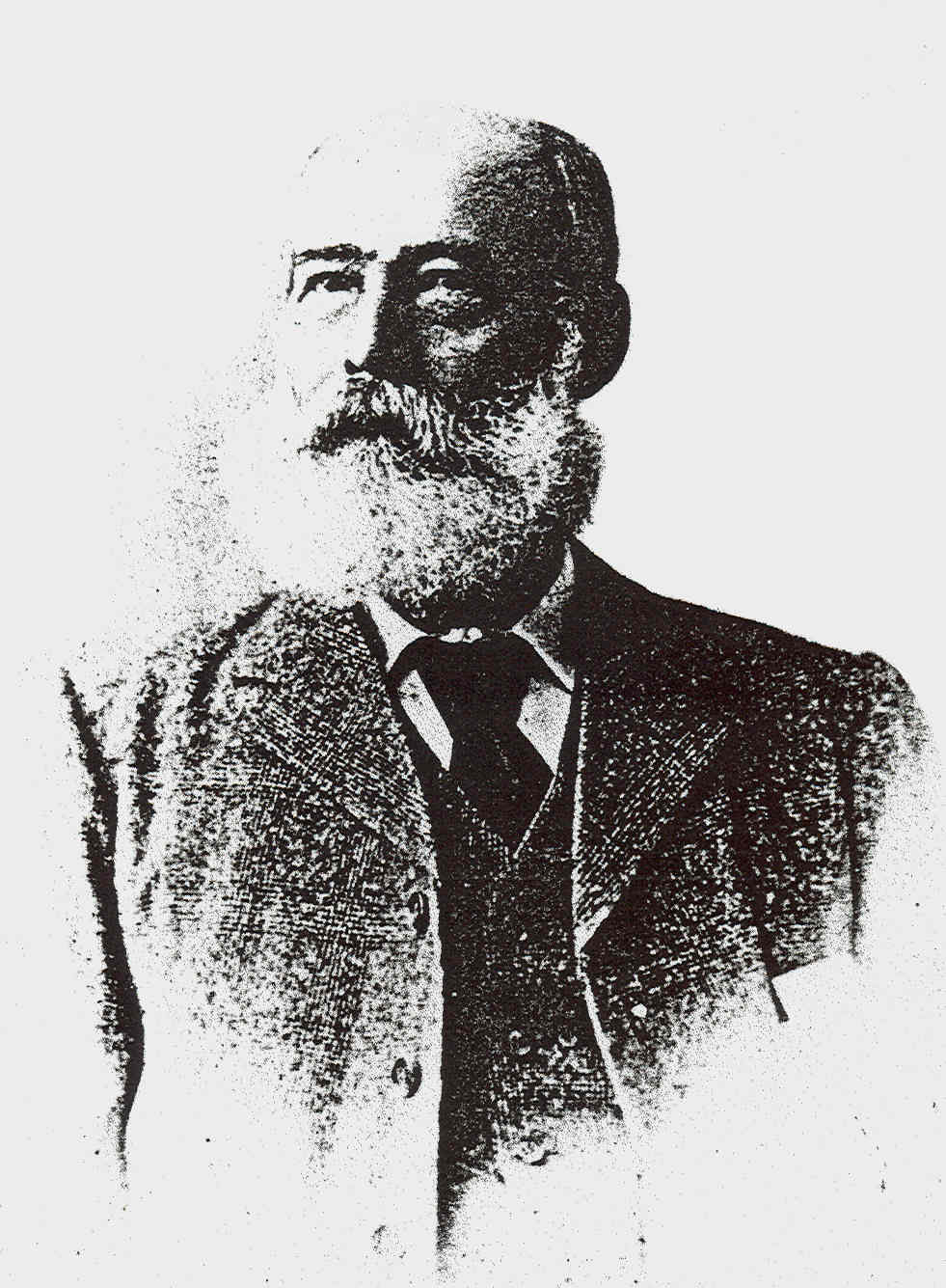
Alfred's work was mainly in surveying for the Government in south-east Queensland, where the town of Brisbane and nearby areas were booming after Queensland separated from New South Wales in 1859, but especially after gold was discovered in Gympie in 1867 and a road was opened from Brisbane to the goldfields the following year. He surveyed much of the land south of Caloundra, and a tree he blazed in 1881 still stands at Pelican Waters today. In late 1883, Alfred (right) was instructed to take a survey crew and make his way up the North Road to Bankfoot House in the Glasshouse Mountains. This was an accommodation house established by William and Mary Grigor at one of Cobb & Co's staging stops. It was close to Mt Coonowrin (Crook Neck), a sheer volcanic plug, for even in those early days the Glasshouse Mountains were very popular with rock climbers and amateur mountaineers. It was also about halfway between the outskirts of Brisbane and the Cobb's Camp Hotel (today's Woombye). From Grigor's, the North Road turned north-north-east towards the settlement of Mellum Creek (today's Landsborough), but Alfred was told to strike north-north-west. Grigor's was to be the starting point for the first survey of a road heading towards the Blackall Range and then following its eastern summits as far as possible, until rejoining the North Road in the vicinity of Yandina.
Copies of Alfred's survey map and written
report still exist, and it is interesting to see that he marked the
accommodation house on his chart, but labelled it 'Gregor's'. The report also
shows the mis-spelling. It is
uncertain how many men were with Alfred, but many crews of that period consisted
of a horse handler, a cook, a scrub clearer and an instrument observer, along
with the licensed surveyor.
All distances were measured from a datum
point in central Brisbane, and 'Gregor's Accomn. House' is shown at the 44 mile mark. Delisser's instructions were to survey a new road alignment to the southern
end of the Range, then to ascend the Range, and then to mark out a northerly route along
the eastern
edge of the escarpment until he was approaching Yandina. Then he was to descend
the Range again and connect with the main road to Gympie near that town. He was
to choose the gradients and curves carefully, so that a future road could be
easily built along his route, with a minimum of earthworks.
Alfred needed to mark out his road in a
way that could be easily followed by later surveyors and civil engineers. This
he did by riding and assessing the best route in short sections. Approximately
each half-mile, a large tree on the route would be chosen, and a large blaze cut
into it with an axe. Every one of these trees would be shown on the surveying
chart, together with its type. Marked on the chart was a Traverse Table, on
which the surveyor indicated the tree number, its bearing in degrees from the
previous tree, the distance they were apart, the type of tree, and the blaze
marks used. The route between the trees was then inked in, showing minor
deviations.
Click
here for first page of Alfred's report
 Alfred struck north from Coonowrin Creek
through country already surveyed into blocks, and after six miles reached the
site of the settlement of Peachester, which would be established within twelve
months. There was an area called 'The Peach Trees' nearby, so he chose an
apple tree for his blaze to avoid confusion. The survey was not helped by the
sticky heat of summer which had now arrived, and the soaking rain of frequent
afternoon storms which drenched his equipment.
Alfred struck north from Coonowrin Creek
through country already surveyed into blocks, and after six miles reached the
site of the settlement of Peachester, which would be established within twelve
months. There was an area called 'The Peach Trees' nearby, so he chose an
apple tree for his blaze to avoid confusion. The survey was not helped by the
sticky heat of summer which had now arrived, and the soaking rain of frequent
afternoon storms which drenched his equipment.
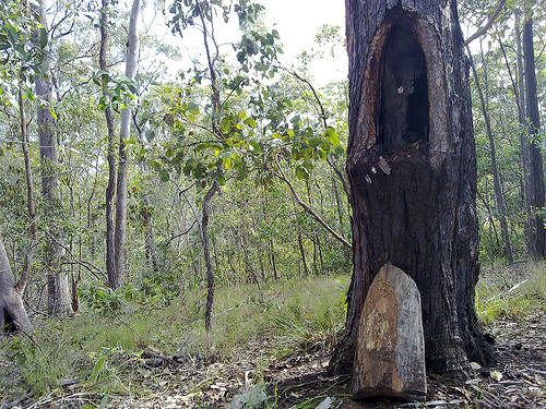
One of Delisser's blazed trees near Mosquito Creek is seen at left. The wooden heart of the blaze has fallen out and is standing at the base of the tree. (Photo courtesy of Neil Ennis).
The way now led though dense scrub and up
'sandstone and gravelly ridges', and he crested the southern edge of the
Conondale Range near the present McCarthy Shute, about two and a half miles
(four kilometres) west along the road from Mary Cairncross Park. This area was
in the process of being settled, and selectors had already claimed much of the
country that Alfred was passing through.
Turning east along the Conondale Range, Alfred surveyed two alternative routes which came together again where 'the Blackall Range commences to run North'. At this junction, Alfred's route crossed a track coming up from Mellum Creek to Mr D. Campbell's property, and he carefully marked this road and 'Campbell's Gate' on his map.
The present location of this point is the main junction to Montville on the Maleny - Landsborough road. He continued east for three more miles, and then followed the edge of the escarpment as it veered to the north, becoming the Blackall Range. Concerned that future settlers may try to prevent his preferred road alignment from passing through and dividing their properties, Alfred wrote in his journal:

Alfred now found himself on a narrow ridge, with Baroon Pocket and the Obi Obi Valley on his left and the coastal plain on his right. He continued on, sometimes finding his way easier as he crossed blocks that had already been selected and were being cleared. He passed through what later became known as Razorback (now Montville), and headed north through the selections of G. H. Bury, J. Caton and J. C. Dixon, who had chosen their land not long before. Near a scrub tree, he saw a rough track coming up the Range to Dixon's selection (now Flaxton) and plotted it on his map, marking it 'To Namba Stn.' This track also led to Cobb's Camp as well as the Namba cattle station, and is known today as Phillips Road. At some later date, the spelling on the chart was amended to 'Nambour'.
There were no settlers north of this point, so Alfred cut his way through the dense vine scrub for another two miles. He blazed two more scrub trees and a bloodwood before finally making his mark on a large gum tree at the 72.5 mile mark. This tree appears on his map to be near the south-eastern corner of the Mapleton State School grounds. Passing across the site of the school, he found a previously-surveyed blazed line coming up from the Petrie's Creek settlement to a point near a swamp, the line continuing in a westerly direction for 1.5 miles before striking south-west at a bloodwood tree towards the Mt Ubi cattle station.
Following this existing survey line as far as the bloodwood, Delisser turned north again through unsurveyed country. It is ironic that this 1.5 mile section, which is now called Delicia Road* due to a misspelling of Alfred's name, is one of the few sections of his survey that he did not originate himself.
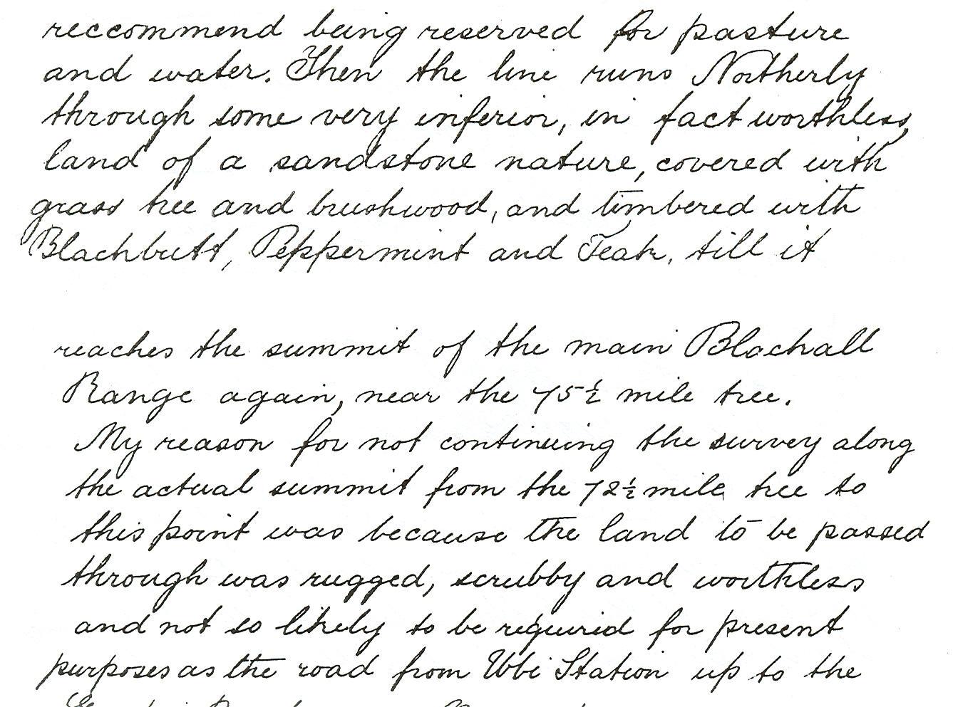
A little over a mile west of the future site of Mapleton, Delisser crossed a creek which he named Pencil Creek because of the pencil cedars growing on its banks. Heading in a north-north-easterly direction, Alfred noted a marked change in the quality of the country. He wrote:
Alfred followed the ridges of the Blackall Range as they descended. He finally reached the Gympie Road at the 85 mile mark, thus completing his survey, having charted 41 miles (66 kilometres) of road alignment from Grigor's Bankfoot House. He completed the map and his written report on 17th March 1884, and was paid a week later.
Alfred Delisser's survey was perfect, for the modern roads follow his chosen alignment almost exactly. The present-day traveller can retrace his survey lines almost in their entirety, although those parts of his route between Crohamhurst Observatory and McCarthy Shute, and around the west side of Cooloolabin Dam remain as unsealed roads.
The complete route between the scrub tree at the 59 mile mark (Mary Cairncross Park) through Montville and Flaxton to his long-vanished gum tree at the 72.5 mile mark (Mapleton) is now wide bitumen.
Because of the sinuous nature of the road, local people have jokingly suggested that Delisser must have been paid by the number of bends he put into the route. Actually, this turns out to be true! Even up to the 1970s, surveyors marking a new route were paid by the 'chainage' (distance covered), with payment loadings depending on whether the land was undulating or level, whether the route had to be cleared to make a passage through or not, whether pegs, blazes or rock cairns were used as markers, and how many corners (and therefore measuring and sighting datum points) were included in the survey.
Be that as it may, the hundreds of tourists who follow the road along the Blackall Range every week would surely agree that Alfred Delisser has given us one of the most scenic and pleasant highways in Australia.
_______________________________
*
Delicia Road is a main road in Mapleton. It runs past the Lilyponds and was crossed by the tramway near the Mapleton Station. It runs along
a short part of Alfred Delisser's route, and was named after
him. In the intervening
years its spelling has changed to Delissa, then Delicier, and now Delicia.